Southwest Colorado Hiking Guide
|
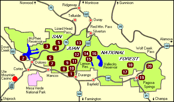
There are hundreds of trails for hiking, biking, and horseback riding in southwestern Colorado. Below is a map and list of 20 such trails in the beautiful San Juan National Forest. |
| Map No. |
Trail | Elevation Range |
Ability Level |
Recommended Use | Length (miles) |
||
| Hike | Bike | Horse | |||||
| 1 | Animas City Mtn. | 6700-8100 | 3 | 5.5 loop | |||
| 2 | Can Do | 6900-7300 | 1 | 1.0 | |||
| 3 | Geyser Springs | 8600-9500 | 3 | 1.2 | |||
| 4 | Priest Gulch | 8100-11,500 | 3 | 7.5 | |||
| 5 | Calico | 8100-12,000 | 4 | 19 | |||
| 6 | Big Al | 8900-9400 | 1 | 0.6 | |||
| 7 | West Mancos | 9800-11,000 | 3 | 10 | |||
| 8 | Dry Fork | 7400-8600 | 3 | 9 loop | |||
| 9 | Animas Overlook | 8920-9000 | 1 | 0.7 loop | |||
| 10 | Lower Colorado | 6960-11,600 | 4 | 21 | |||
| 11 | Hermosa | 8000-9000 | 3 | 21 | |||
| 12 | Pass | 10,600-12,000 | 3 | 2.2 | |||
| 13 | Upper Colorado | 11,000-12,000 | 4 | 20 | |||
| 14 | Spud Lake | 10,300-10,900 | 2 | 1 | |||
| 15 | Lost Lake | 8820-8860 | 2 | 0.5 | |||
| 16 | Eileen | 7720-8860 | 3 | 2 | |||
| 17 | Piedra | 7000-7500 | 3 | 12 | |||
| 18 | Williams | 8440-9300 | 3 | 3 | |||
| 19 | Reservoir Hill | 7100-7500 | 3 | 0.75 | |||
| 20 | Treasure Falls | 7800-7900 | 2 | 0.5 | |||
|
Ability Level 1 = Barrier Free 2 = Easy 3 = More Difficult 4 = Most Difficult |
|||||||
|
Length Distances are one way unless loop is specified. |
|||||||
|
For More Information |
||
|
San Juan National Forest |
Durango Visitors Center 111 S. Camino del Rio Durango, CO 81301 970-247-0312 |
Columbine Ranger District 367 S. Pearl St. Bayfield, CO 81122 970-884-2512 |
| Mancos-Dolores Ranger District 100 N. 6th St. Dolores, CO 81323 970-882-7296 |
Pagosa Ranger District 180 Pagosa St. Pagosa Springs, CO 81147 970-264-2268 |
Pagosa Visitors Center 402 San Juan St. Pagosa Springs, CO 81147 970-264-2360 |
© Copyright 1999 Ute Mountain Casino ![]()